As a part of planning where I would go, at what airports I would land, I often let whimsy guide my hand.
Decorah was one such place. I needed to land in Iowa…where? All Spring I’d started my work morning by logging onto The Decorah Eagle Cam. I watched those baby eagles, worried about them, observed their interactions with each other and the parents. Would they survive the surprise Spring snow? Would the last to hatch (I called her #3) manage to get her share of food and not be destroyed by #1 and #2? It was a tough job, but I wasn’t alone..thousands watched, learned and marveled at nature. Without perspective, its hard to appreciate how big this nest is. 6-8 feet across, 4 feet deep. Many of those "twigs" are wrist sized.

 Sometimes the keeper of the camera, would move its focus away from the nest and reveal surrounding countryside. Ah Clues! I soon had a clear picture of nest location with a little help from Google. Turned out that Decorah has an airport (DEH) and it offers a courtesy car. Decision made.
Leaving Indiana, my first stop is in Wisconsin, at Platteville (PVB) just a few miles east of the Mississippi River. Just as I finished filling up with cheapest fuel so far on this trip - $4.90 per gallon, I spotted a Jet taxiing up to the FBO, followed closely by an arriving helicopter – military Black Hawk. Oh, and then three unmarked police vehicles. Guys in suits climbed out of the jet. Guys in officer uniforms from the copter, and very serious looking police stood guard. After all the suits and uniforms went inside I approached the police and asked what was going on. They indicated they could not say. I was also told that I could not enter the FBO. Hmmm… I took pictures, as best I could.
 Eventually I did get permission to go inside and use the bathroom, but a lot of very serious men kept a very close eye on me. No one had a clue what was going on, or would/could not say. I hate not having curiosity appeased.
But I was telling about Eagles of a feathered kind. Driving to the nest site felt like a pilgrimage. To see a place thousands of miles from my desk, standing along that familiar road, looking up at the nest I’d spent so many hours watching was an incredible experience.
The parents had delivered a lot of fish to the eaglets and knowing a hatchery was nearby, I had a theory. I spoke with a man at the hatchery and he confirmed. Some of the fish where “stolen” from the holding ponds, but most were donated to the eagles. Each morning the crew scoops out any fish that have expired during the night and the eagles roosted in nearby trees waiting for free breakfast.
Parents stay in the immediate vicinity of the nest, but at least one of the eaglets has been tracked into northern Wisconsin. No, I didn’t see the eagles, but it wasn’t really necessary, I was content with seeing the nest site in person.
The balance of the flight on to my next stop at Buffalo, MN was uneventful, but slow with constant headwind. Total flight 435 nm. 4 hrs 40 minutes. States: Indiana, Illinois, Iowa, Minnesota.
It’s true. Every word of this post.
For those of you who don’t know, my name is Joyce Rust. Since Saturday I’ve been a guest in the Indiana home of Joyce Rust. Note the word “guest.” That means exactly what it seems. . . there are two of us.
Two years ago I Googled myself (it was all the rage) and discovered that I owned a grass airport in Indiana. What a nice surprise, I’d always wanted one! Maybe a year later I looked for this Joyce on Facebook – and there she was. We exchanged a couple messages, moved to email and started to learn a little about each other. I renamed us “Joyce West” and “Joyce East”.
When I learned Joyce East is also a pilot…and flies a Cessna, I knew we had to meet and that someday I would land on her grass strip. Saturday I did. Well technically I arrived over the strip, circled fruitlessly for over 10 minutes and flew to the nearby town airport. Ever try to find a grass strip in farm country? Every other field looks good to land on, the farm buildings look like hangars.
Joyce is a wonderful person who has made me feel like family. We’ve had fun watching people’s faces when I’m introduced. “Hello. I’d like you to meet my friend, Joyce Rust.”
“Your joking, right? “ “Nah, you got to be making this up.”
Yesterday Joyce East flew me to town, after circling a couple times to point out landmarks so I could find the field. Two hours later I fulfilled my goal to set down on Rust Landing.
 Our similarities grow with every conversation. From simple things like food preferences to our way of approaching challenges. I believe I’ve found a lifetime friend.
Departed from Williamsburg (JGG) at 9:25 am. Beautiful clear blue sky..what a treat. Passed Richmond VA 15 minutes later flying at 3,500 and outside air temp a comfortable 65 degrees.
At 10:25 spotted the first non-flat land - hills and then mountains. Later learned these were the Appalachians. I flew over and among them, snapping photos and marveling at their beauty, so different from, and yet as wonderful as those I've enjoyed in the Northwest.
 My first goal for today was Huntington WV to land at Tri-State airport (HTS), but just past Ingalls (HSP) and Moomaw Lake, both in VA...

 I passed into WV and spotted Greenbrier Valley (LWB) in Lewisburg WV. This airport, nestled beautifully among the mountains was too good to pass up - it became my spot to add WV to the map. Also my spot to switch from shorts to jeans - 54 on the ground. I add cabin heat on departure and its welcome as outside temp is under 50 at 3,000.
 From there to the Ohio River, I was surprised at the number of mines...I assume coal... that were often 3-4 in view at one time.
 The rest of the countryside was treed with steep river gullies, valleys and peaks. Farms are tucked into green clearings. Fall color is beginning to show and I suspect will be amazing in just another couple weeks...wish I could be here to see it.
 Approaching the Charleston area ceilings lowered from 7,000 to 4,500 and rain squalls started. For the next 60 nm I flew around and through rain squalls, with visibility remaining at 5 miles or more, but sometimes going to 3 for short spurts. Spotting the Ohio River, I crossed over, flying from WV to OH to KY within minutes! Here is Huntington, WV.
 Landing at Ashland at 1:25 - yes those are raindrops.

I take a break, order fuel ($5.45) and check weather ahead. The heavy winds continue in Indiana, just 228 miles ahead - but tomorrow, Saturday, is supposed to be clear and much calmer so I decide to spend the afternoon and evening in KY.
 Judy welcomed me, listened to my tales of travel, provided a courtesy van and map. Thanks for everything, Judy!
I Poked around the area for a bit then dinner at Ruby Tuesdays - lobster, shrimp and crab cakes with fresh green beans and cheese/herb biscuits, all perfectly prepared and washed down with blackberry lemonade.
I sit here at in a second floor room with a close view of a wooded hill and meadow with a feeding doe...calm and private... I can leave the curtains open.. and I thought dinner was the perfect end to a good day of flying. I can see the skies clearing already for my morning departure.
Went to the beach today, Virginia Beach. A tourist area that post-season is quiet, almost eerily so. Rows of shops full of cheap tourist gee-gaws, empty but for bored employees. But I didn’t come to shop, I came to put feet into the Atlantic Ocean. So that is what I did. Now I've waded in both oceans - on each side of the Continent.
 Surprise! The water is not cold. Not quite as warm as Hawaii, but darn close. I could have comfortably swam, and wished I’d known it was possible since the day was perfect for it with sunshine and a soft breeze – probably low eighties.
This little guy was busily cleaning up anything edible from the surf’s edge…fellow blogger Sondra has inspired me to try for bird photos and finally I got one worth posting!
 My sweet tooth that demands ice cream led me to this spot. A long row of self-serve spigots labeled with flavors then a longer row of toppings - fresh fruit, cookie bits, crushed candy bars, nuts, etc. If you’ve ever heard or thought about putting it on ice cream – this place had it. Cost? Just 45 cents per ounce. Somehow I managed to pile on $6.26 cents worth. Sure was good, try it if you see the store.

 Both ways we had to drive through this tunnel, which goes UNDER a body of water strangely called Hampton Roads. Do not care much for tunnels. Never been in a tunnel under water..didn’t like the idea. Positive that roof above our heads was bulging downward. I told my niece that “just one drop of water on the windshield and your going go to have an out of control adult on your hands.” She found it uproariously funny. Not. Did I mention it was miles long? Well, it was. But on the way back, I was better prepared so took a photo..(see the bulge?)
 Happy once again, to have made it through Hampton Roads Beltway – alive, I spot the proverbial light at the end of the tunnel.

For the entire drive military was very much in evidence. I saw ships at dock at Naval Station Norfolk, but too far away for a photo. Lots of fighters passing over Virginia Beach heading out to sea, two by two. A lovely airshow. I'm guessing they came from either Langley Air Force Base or Felker Army Air Field as both are nearby. Lots of Chinooks buzzing about too. This area is heavily military with housing and forts and bases at every turn. My nephew is stationed here in the Navy on one of the big air craft carriers. What isn't military is historical and I'll tell about that later.
I stood upon the spot from which powered flight began.
I could feel the tingle of excitement, the rush of fear, the realization that this was it – the time to fly - that Orville Wright had to have experienced that day. December 17th, 1903.
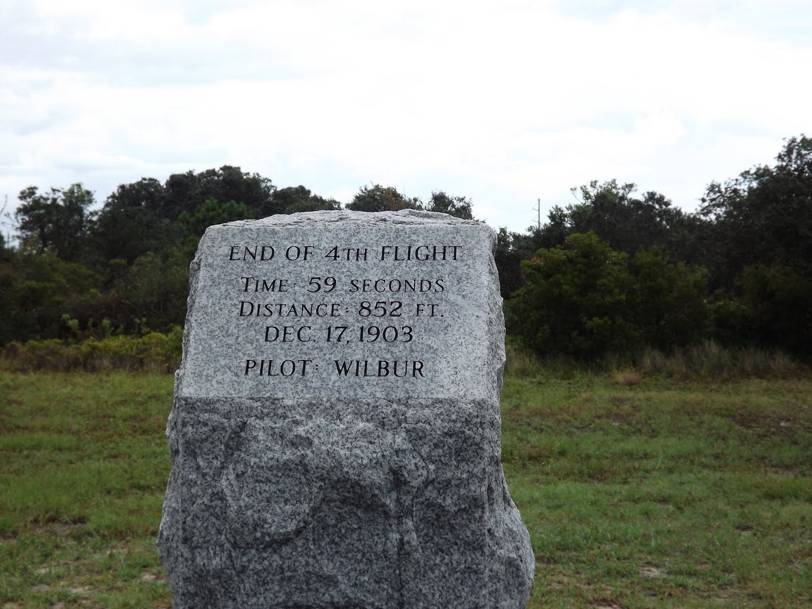
 Of course I had read about the length of these flights, but the distances, and how short they were, is brought graphically to life with these granite markers, commemorating each one. (Phot taken from launch point)


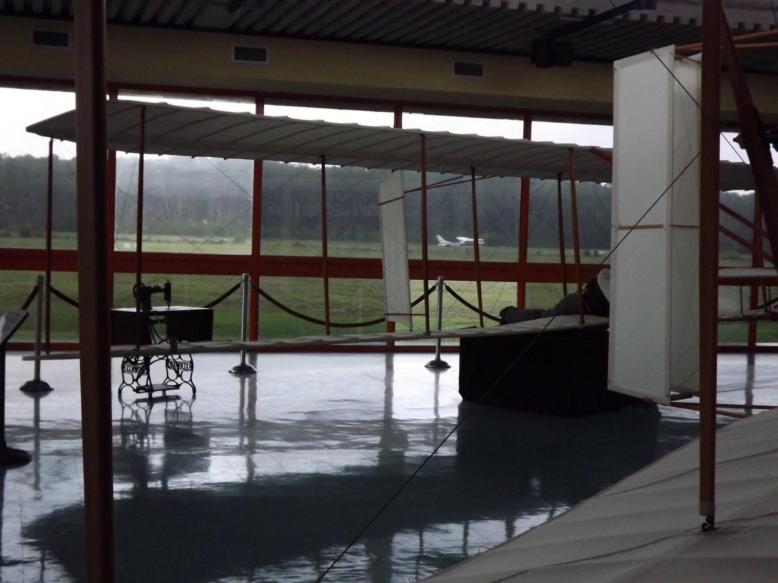
 The weather was warm, but very wet. Rain squalls moved through with regularity some so hard that those with umbrellas or plastic ponchos sought shelter. But nothing stopped visitors for long. People walked the “flight line”, climbed the hill to walk around the monument, and wandered in and out of the two visitor centers. One featured a life size replica of the Wright Flyer. In this photo you can see Path parked on the edge of the taxiway outside.
 The other center was to commemorate the 100th anniversary of flight and featured the planning, building and flights of a reproduction Flyer. Outside is a wonderful series of statues depicting the first flight. Here is Murphette ready to go with Orville.
 On top of one of the tallest of the dunes at Kill Devil Hills they built a monument to flight. But first they had to stabilize shifting sands with plants and grasses. Now the sand dune where the Wrights tested theories with gliders is a solid hill with paved paths leading upward to the summit. I joined the devoted who climbed to stand and marvel at this place.
 With weather not conducive to flight, I settled in for the night. At dawn the joggers arrived, their silhouettes black against the monument as they jogged past then down the path from the summit. To them merely a challenging run..did they not sense the majesty of where they trod?
 To my pilot friends, I say – make the pilgrimage. To those who travel on land – come and learn what makes flyers so devoted to aviation.

Thursday Sep 22nd
Dodging military Restricted Areas, huge towers, clouds and rain squalls I flew across North Carolina seeking the Atlantic Ocean.
I’d left Atlanta the day before, liftoff at 3:15…much later than I liked, due of course, to low clouds. Here is Fulton County Airport on the west side of Atlanta.

 Even though I’d had a lovely long visit with my friends, it was hard to leave them, especially their precious daughter who had begun to call me G-ma Joyce. What an honor. The bear in this picture is “Murphette” named in honor of the couple who gave her to me as a mascot for this trip.
 10:25 I’m passing Augusta, read about and now seen then over the Savannah river into North Carolina 8th new state on this trip.

 5:10 I arrive in Orangeburg, South Carolina and decide to stay the night. With Path tied securely and armed with map and recommendation, I drive into town for dinner and a room. Spent so much time seeking a souvenir keychain for my son who collects them that it is soon too late for a big sit down meal. I spot Chick-fil-a and remember being told that this chain is a “must try” while in the south. Approaching the door I spot ..a cow and remember that cows are the spokespersons for their ads. Tourist, so must ask for a picture
 – the cow is delighted as is his attendant who escorts me inside where I’m introduced to the owner and his wife who are excited to make suggestions as to the ideal choices from the menu. It turns out they are having an “eat breakfast for dinner” event so servers are wearing PJ’s!
With a bag of treats in hand I return to my room at The Southern Lodge on St Matthews Rd (I promised the very nice owner to give him a mention as his place was very reasonable, clean and comfortable.) Settled in and ready to eat and relax I enjoy mini chicken biscuits, made with real, not processed, chicken and tiny cinnamon buns which are not overly sweet. Hand squeezed lemonade rounds out my less than standard, but oh so delicious dinner. Then the floor show starts. Huge cracks of thunder drag me out the door where, with other guests, I watch nature’s entertainment for several minutes as lightning streaks and thunder rolls. Sure hope this isn’t over the airport I think, concerned for Path sitting out on the tarmac. But that was just the beginning. Thirty minutes later the rain arrives…and boy howdy! I opened the door again, and stayed inside, as to do otherwise would provide me with a second shower. Rain in buckets – no barrels, blowing in waves. Waterfalls from overflowing eaves, the walkway a river threatening to flow inside onto the carpet. I looked briefly, took a photo, and retreated. Hmmm maybe I shouldn’t have wished Path could have a bath!
 Morning is clearer than I’d expected, so wish I hadn’t elected to sleep in and be lazy. 9:25 when a wet Path lifts off. 25 nm later we’re over the Santee Wildlife Preserve along Lake Marion, with light rain.
 Which brings us back to the beginning of today’s tale – flying at 1,200, under clouds avoiding things best avoided. I do manage to note that this is lovely country with farms, lots of trees, homes on large lots, lots of brick buildings. At last land gives in to water as I cross the Alligator River

Then Albemarle Sound
 And there, just across Roanoke sound, past that little strip of sunlit land, is my goal… Atlantic Ocean and an airport called First Flight.


 Sometimes the keeper of the camera, would move its focus away from the nest and reveal surrounding countryside. Ah Clues! I soon had a clear picture of nest location with a little help from Google. Turned out that Decorah has an airport (DEH) and it offers a courtesy car. Decision made.