Thursday, December 16, 2010

Lone Pine California

I stopped here on my way to AZ September of 2009. Why? Because the movie “Tremors” was filmed just south of town. It was my intention to land for a quick break and then try to spot the filming location as I departed. Approaching the area, flying down the Owens valley from the North, I spotted the Alabama Hills laying northwest of town. One of the most amazing mass of rock formations I’d ever seen, anywhere.

Finding a courtesy car available at O26 I decided that a quick drive for a closer look would be worthwhile. In no time I realized that this area required me to devote the entire day to exploration. I found a modestly priced, clean room and got pointers from the locals on where to go and what to see.
Alabama Hills.
Movies have been filmed here from the early days of Bogart, Hop Along Cassidy, and John Wayne to Mel Gibson and Clint Eastwood. There is a museum/theatre in town that does festivals of films made in Lone Pine. Unfortunately it was closed the day I was there. Driving into and among the hills, I kept taking photos of the rock formations and would say “no more” until around a corner would be another view I just had to try and capture.

I came across a film crew but my curiosity was NOT appreciated, and they shooed me away after admitting it was a car commercial being filmed. I had snapped this photo before they accosted me, and figure it’s long enough ago that my sharing now couldn’t make any difference. Anyone recognize what kind of car this is?

Mt. Whitney.
I snapped this mountain when driving out of the airport.
It was later in the day that I was told it’s very popular with climbers and extreme hikers. Oh, that explains all those buff young men in town!
Directed to the road leading to Whitney I drove up and up on a narrow, just barely two-lane strip cut out of the side of the foot-mountains (too big to be foothills). One mistake here and it’s goodbye – no guard rails and a long way down.
To put a perfect end on the day I took myself out to the local upscale dinner house, Seasons. Table cloths, candlelight and food every bit as delicious as the scenery I’d taken in all day. Chocolate mousse cheesecake for dessert.

This is a place I intend to re-visit when I’m traveling with my camper so I can stay and explore to my heart’s content.
Thursday, December 9, 2010

Roosts

We fly over and spot them as waypoints as we travel. We touch down and visit for a rest break, fuel, or to visit for an hour or a day. We call our roosts airports and they are very special places.

Gateways to adventure.
Orcas Island, San Juans.


Places we land to camp where others cannot.

Cavanaugh Bay, Priest Lake ID

Daybreak, WA

Enjoy a meal while watching planes come and go.

Flying M, OR. Favorite brunch spot!

Opportunities to meet new people, visit friends and family.

Thompson Falls, MT. Love this place.

Each airport offers its own challenge, be it wind, terrain, length/condition of runway or heavy traffic.

At the end of a long trip coming home, the sight of that strip of concrete, patch of grass or that welcoming beacon at night say “Here I am, come home and Roost.”


Friday, December 3, 2010

Trying something new here..

I found a new toy! Can't resist playing and sharing.

CampHouse Trip #1

Click to play this Smilebox slideshow
Create your own slideshow - Powered by Smilebox
This free photo slideshow customized with Smilebox

Tuesday, November 23, 2010

Thousands of Steps

In September I started walking. My first walk was under 2 miles and my legs and feet hurt, a lot. I was, however, determined to get into better shape so I could enjoy hikes to beautiful places (thanks Diana).

I live out in the country and there are few roads to walk along safely, and no walking paths. With limited options, I came up with a method. Pick a road and walk until tired, then call my husband to come and retrieve me. No need to gauge how far back home is, how far I’ve traveled.

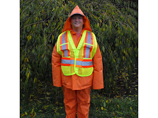
With each subsequent walk I increased the distance, and soon discomfort was no longer an issue. On days when after work obligations prevented a walk, I missed the exercise! Could I be hooked on hoofing? Soon I ran out of daylight before being done, so purchased a safety vest and an LED headlamp so drivers could see me. With rainy season upon us, I bought a 2-piece rain suit. It’s bright orange and very stylish.

I started picking routes that were longer, that included hills – long steep ones. I was determined to make 5 miles without aches and pains, and doing so at a brisk pace. I managed 4.6, 4.8 and several at 4.9 but kept missing that elusive five. Then one day there it was – 5.9, almost a mile past my goal. Yippee!

I’m now doing 4 miles on those nights when it’s really dark and wet and cold. On weekends or nicer evenings 5 miles is usual and my new goal is 6. My doctor was making noises about elevated blood pressure, but last week she was amazed by the positive change. Walking is my health plan. I intend to enjoy a long healthy retirement. Right now, I'm going walking.

Wednesday, November 17, 2010

New Direction

I’ve been blogging long enough now that if a few days go by and I’ve nothing new to post, I miss it. So with winter weather putting a stop to most flying there will be no new adventures to share. Of course there are a few past events to document, but they don’t provide me with the same satisfaction since I’ve already finished with them and moved on. I’m still going to keep this blog mostly about flying, but have decided to allow some of my other passions to edge their way in.

Scrapbooking. After the adventure itself is over, this outlet allows me to document and relive the event while appeasing my creative side. I’ve been a Scrapper longer than I’ve been a pilot so merging the two makes sense. I started as a paper scrapper, often using my computer to create bits and pieces. Purely digital scrapping was an easy step, and one I’ve embraced enthusiastically. With digital I can move something that doesn’t look right (it’s not glued down). That really cool piece of paper or ribbon can be used over and over. I can scrapbook anywhere I can use a laptop. No need for tables, storage and an array of tools that would impress a car mechanic.
Here is one of my favorite pages. (Click on the image to see full size)

If your interested in trying Digital Scrapping, I’d recommend a piece of software called Adobe Photoshop Elements. It’s not as complex nor as expensive as the full Photoshop that professionals use, but still has plenty of powerful tools. Then you could visit any number of web sites to download free digital supplies to get started. A couple of my favorites are scrapgirls.com and designerdigitals.com.

Wednesday, November 3, 2010

Purple Haze

Tonight I invited my friend Ed to go flying. Our mission was to enjoy Fall color from the air, and get some photos. I remembered a spot along the Cascade foothills where I’d seen riots of color in past years. I was anxious to share this treat with Ed. Unfortunately a high system of Cirrus and Altocumulus clouds blocked just enough sun to ruin photos. We could see and appreciate the color, but vibrancy for photos requires sunlight.

Mountains, however, look really good in filtered sun, especially when it’s setting.
Mt. Hood
Mt. Adams in pink with St. Helens in the foreground.

By this time the sun was sinking rapidly to the horizon, and our attention was drawn to the show. We got color, just not in the way we expected!


I’ve seen a lot of sunsets, but never before this phenomena. The very air was colored…in a Purple Haze.


Purple haze all in my brain
lately things don't seem the same
Acting funny and I don't know why
excuse me while I kiss the sky

Sunday, October 24, 2010

Second Step


Today I found it.
After visiting 10 dealers in two states, spending hours searching on-line, studying photos, and walking through what seemed like hundreds… I found my new traveling home! In my search I found units with features I liked, but never one with ALL - size, condition, room, comfort and price. Until now. I am the owner of a fifth wheel. Here she is.

Now it’s time to tell why I needed a fifth wheel.

It was my intention, upon retiring, to go flying, a lot. To land in every state, traveling until finally getting all the flying I want. A friend pointed out that a lot of money would be spent on hotels with this style of travel. To solve this problem, The Shuttle Method is conceived.

From Point A, I’ll pull my fifth wheel; say 300 miles to Point B. I’ll park it and make my way back to Point A by catching a ride with another pilot or by taking a bus or train. Next I fly back to Point B which is now my new base of operations. From here I can explore, camp, and make local flights until I’ve seen everything I want. Repeat as needed.


I'm so excited about my new CampHouse that I had to include this interior view. I'll make the three-hour drive to Oregon early next month to bring her home, with a side trip to a hot springs..got to try her out!

About 140 working days left until The Shuttle Method begins.

Wednesday, October 20, 2010

Winter Splendor

With Winter approaching fast, I’ve found myself thinking about this flight so thought I’d share it. In February of 2006, one of those magical winter days arrived with cold, clear skies inviting pilots and planes to come play. Michelle and I, flying my 172 left Chehalis at 8:00 am and spent the entire day exploring the mountains of Oregon.

Here we are at Country Squire with Mt Hood as a backdrop.

Then we got up close and personal with Mt. Jefferson. Please note that this photo was not zoomed in.
You cannot always fly this close to mountains, sometimes winds or other conditions make this unsafe, but today all the peaks had the welcome mat out.
Here is Mt. Washington.


This area along the Oregon Cascades from Jefferson south to Mt Bachelor are all set in an area that was previously volcanic. This is Three Finger Jack with The Sisters in the background.


Our flight required a great deal of circling to get just the right picture. Outside air temperature was in the upper 20’s and we had a window open for much of the flight – Darn near froze, but sacrifices must be made to “get the shot.” I was flying and Michelle would say “wing up” or “turn more west” as she focused and framed.

We stopped at Bend OR for fuel and lunch. Professional Air is a great FBO and treated us like royalty. The runway was clear but snow remained in patches on the taxiways and parking, much to my delight – first time on snow. So we took our signature “Foot Photo”. Don't laugh. I can go back through the foot pix and remember who what when where. It really works.


Now we flew southwest and visited Mt. Bachelor and the Three Sisters. Note old cinder cone in the foreground, and Broken Top at the near right.


Setting sun as we approach home airport and the end of a perfect flying day.

Friday, October 15, 2010

Goin' South

A friend said "Let's go have some fun."
With us this means flying someplace. We took off (after the blasted fog burned off) to go to Oregon. Perfect conditions with smooth air, great temperature, and unlimited visibility. We had not flown together (in separate planes) before. Pilots negotiate who will lead. Slow plane typically, so I throttled way back to let Judy take the lead. Amazing how much less fuel I burn with airspeed at 100 knots or under. Also decided in advance, is how close we will fly - we settled on 1/2 mile minimum.
Crossing the Columbia river just southwest of Kelso.

Our first stop was Salem, OR. Met a friend of Judy's who took us to his farm where we were encouraged to harvest all the veggies we wanted.

Leaving Judy's plane behind we made a quick run south to Lebanon so I could fill up on cheap MoGas. We also wanted to visit with the couple that runs the FBO. Dana and Larry are the best!
This is somewhere over northern Oregon. Love having pictures of my boy in the air!

Friday, October 8, 2010

Steps to Freedom


With retirement and travel less than 8 months away (Yes, I AM counting!) A lot of planning and preparation is underway.

I rented an entire room at our local fairgrounds for their bi-annual Community Garage Sale. Hauled in 4 truckloads of Halloween and Christmas decorations. I know, that is a LOT, but I loved to decorate a lot, and acquired things for 42 years.


At the end of the sale, I’d said goodbye to some special friends. It was hard to make the cuts, as so many memoires were attached. Then a friend said “If you’re keeping it because of how it makes you feel, then take a picture.” So I took a lot of them, and will create a book of Fuzzy Feelings that I can bring out whenever required.

With each sale, I found myself feeling lighter and freer. Now I’m weighed down by the money I made and into the retirement fund it goes!

Wednesday, September 22, 2010

Spotted Bear (8U4)


Since I started flying, I’ve made at least one trip a year to the picturesque state of Montana. This year, I decided it was time for a visit to a back country strip. Tucked into a valley, with easy
approaches, and a go around possible, the strip still offered a challenge in the form of a dog leg. This would be the perfect spot to introduce my friend, Randy to airplane camping.

Spotted bear is a few miles east of Flat Head Lake, between the Swan and Flathead Mountain ranges. Hungry Horse Reservoir lies to the north, the Flathead River running out if it and curving past the strip. I used my favorite method of checking out new spots, by “flying” to 8U4 with Google earth. Fellow pilots – if you haven’t tried this, I encourage you to do so. While the trees are not 3D, mountains and hills are, allowing for a fairly accurate picture of what you’ll be flying into.
Landing to the North
Approach and landing required close attention, but were not terribly technical. We were the only people on the field, or in the campground. (Good tiedowns, bring your own rope) A dirt road that runs parallel to the field along the west had a surprising amount of traffic. We later learned from some forest service people who came out to do maintenance that in addition to a guest ranch, several outfitters have facilities in the valley.

We hiked off into the trees, seeking the river and found it. So many wonderful stones of green and pink with mica and stripes of white, I found it hard to choose just one to take as my usual souvenir.


The plan was to camp overnight and a darn good thing too. Clouds and rain moved in during the late afternoon and soon the downpour was so bad we huddled in the tent. Before nightfall the tent began to leak through the roof, and we hoped to stay dry enough to sleep. We did stay warm and mostly dry in our bags but awoke to a dripping cold morning. Light rain continued intermittently and clouds were nearly to the ground over the runway. A fire boosted our dampened spirits (Thank you to whomever left that pile of firewood!) as did cups of hot chocolate.Wet, Cold, Dreary

Mid-morning the sun began to peek out and lovely blue holes appeared, but I was uncertain of ceilings around the corner. Then I heard a plane! A Cessna 206 landed and this local pilot described a route out to the north that could be easily and safely flown. He even offered to lead the way if I would wait until he finished his business with the cowboy he’d flown in to see. Randy and I hurried to break camp and pack the plane, finishing just before Noon. The skies were looking very good by this time, so I made the decision to depart, first leaving a thank you note on the 206.
Camp before the rain!

For those who might want to drop in at Spotted Bear. In spite of the name, rangers assure me bears are not an issue, just use common sense. There is a vault toilet, good campsites with fire pits, no drinking water. Flight time to Kalispell (S27) is around ½ hour following the Hungry Horse Reservoir, less if you skip the scenery and go direct. But why would you?
Hungry Horse departing North

Tuesday, September 7, 2010

Republic Pirep

For you non-flyers, pirep is short for pilot report. We provide these to flight watch as we travel so other pilots have real-time, real-life information on flying conditions.

Republic, WA. This little town in the northeast part of the state really knows how to put on an event. What seems to be the entire town turns out, volunteering to make sure pilots feel welcome – and we do.
Airport located above Lake Curlew, tucked into a beautiful valley.
Plenty of grassy parking for putting up tents. Judy flew with me in Path and we met Bob and Diane to camp together.

Food above average at fair prices. Breakfast is the usual pancakes to which they add ham and cooked to order eggs! Saturday night is the steak feed. They load a beautiful chunk of steak on your plate which you take to the apple wood grill and cook to your own satisfaction. Added is a baked potato, coleslaw, and baked beans.
Live entertainment on Friday and Saturday nights. They have a local “Elvis” that is so good I thought they were playing a CD!
Area tours, at no charge, include a boat ride on Lake Curlew. Yup, a storm was coming in, but blew by without rain.

Visit to and ride on Antique merry-go-round, which is a real work of art.

Townspeople come out and wander among the planes, learning about aviation and sharing info about their beautiful corner of the world.
This Mom and her two boys were especially eager to get involved and inspired us to load them up with information and encouragement.


This warbird, a Russian Yak (I think) flew in providing an impromptu airshow.

Because everyone attending is so relaxed and happy, the making of new friends and renewing of old acquaintances is guaranteed.
I’m already looking forward to visiting Republic again next year. Fly-in is held the last full weekend in August. Hope to see some of you there!